| CPC G01S 7/4972 (2013.01) [G01S 7/497 (2013.01); G01S 17/10 (2013.01); G01S 17/42 (2013.01); G01S 17/86 (2020.01); G01S 17/87 (2013.01); G01S 17/931 (2020.01)] | 20 Claims |
|
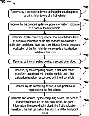
1. A method comprising:
receiving, by a computing device associated with a second vehicle, a first point cloud captured by a first light detection and ranging (lidar) device of a first vehicle, wherein the first point cloud includes points representing the second vehicle;
receiving, by the computing device, pose information indicative of a pose of the first vehicle;
determining, by the computing device, that a confidence level of accurate calibration of the first lidar device exceeds a calibration confidence threshold and a confidence level of accurate localization of the first lidar device exceeds a localization confidence threshold;
capturing, using a second lidar device of the second vehicle while the second vehicle remains stationary, a second point cloud;
receiving, by the computing device, a first localization transform associated with the first vehicle and a first calibration transform associated with the first vehicle, wherein the first localization transform is usable to transform between a coordinate system of the first vehicle and a world coordinate system;
receiving, by the computing device, a third point cloud representing the first vehicle; and
calibrating and localizing, by the computing device, the second lidar device based on the first point cloud, the pose information, the second point cloud, the first localization transform, the first calibration transform, and the third point cloud.
|