| CPC B60W 30/085 (2013.01) [B60W 30/18109 (2013.01); G06V 20/588 (2022.01); G08G 1/082 (2013.01); B60W 2552/53 (2020.02)] | 21 Claims |

|
1. A method of inferring a stop line for a vehicle at an intersection, the method comprising:
by a processor of a vehicle, while the vehicle is moving along a reference path on a first road in a geographic area:
accessing map data for a map, the map data comprising data representing a plurality of roads in the geographic area, wherein the map data segments each of the roads into lane segments;
detecting from the accessed map data that a traffic control measure is located proximate an intersection that is ahead of the vehicle along the reference path;
performing first operations to detect a stop line for the detected traffic control measure that is painted on the first road before or at the intersection;
in response to no stop line for the detected traffic control measure being detected, performing the following second operations to obtain an inferred location of the stop line:
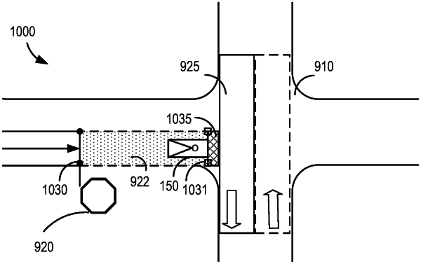
identifying, as a restricted lane, a lane segment of the first road that (i) includes an entry line proximate a location of the traffic control measure and (ii) extends into the intersection, wherein the entry line at least partially defines a boundary of the restricted lane;
identifying, as a nearest lane conflict, a lane segment of a second road intersecting the restricted lane;
determining whether the entry line of the restricted lane is within a target distance of the lane segment of the second road intersecting the restricted lane;
setting the inferred location of the stop line to a location of the entry line responsive to a determination being made that the entry line is within the target distance of the lane segment of the second road; and
performing the following third operations responsive to a determination being made that the entry line is not within the target distance from the lane segment of the second road:
initializing a location of an inferred stop line as the location of the entry line of the restricted lane;
advancing the location of the inferred stop line a distance away from the vehicle and towards the nearest lane conflict;
iteratively repeating the advancing until the location of the inferred stop line is at the target distance from a nearest boundary of the nearest lane conflict;
setting a final location of the inferred stop line as the location of the inferred stop line at completion of said iteratively repeating;
refining the final location of the inferred stop line based on at least one object perceived in an environment using sensor data, wherein the at least one object excludes any traffic control measure; and
setting the inferred location of the stop line as the refined final location of the inferred stop line.
|