| CPC G06T 17/05 (2013.01) [G01S 17/89 (2013.01); G01S 17/931 (2020.01); G05D 1/0231 (2013.01); G06N 20/00 (2019.01); G06T 15/06 (2013.01); G07C 5/02 (2013.01); G05D 2201/0213 (2013.01)] | 20 Claims |
|
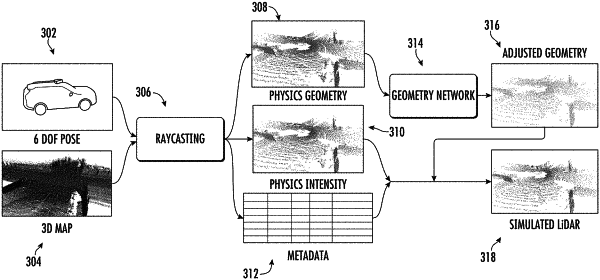
1. A computer-implemented method to generate synthetic light detection and ranging (LiDAR) data, the method comprising:
generating, using a physics-based simulation engine and based at least in part on an object in an environment, an initial point cloud that comprises a plurality of points descriptive of the object; and
generating, using a machine-learned geometry network and based at least in part on the initial point cloud, an adjusted point cloud,
wherein the machine-learned geometry network was trained by evaluating a loss over synthetic point clouds generated using the machine-learned geometry network and ground truth point clouds collected by a physical LiDAR system, the loss configured to correspond to a perceptual similarity between the synthetic point clouds and the ground truth point clouds.
|