| CPC G06F 30/13 (2020.01) [G06F 30/12 (2020.01); H04L 67/02 (2013.01)] | 20 Claims |
|
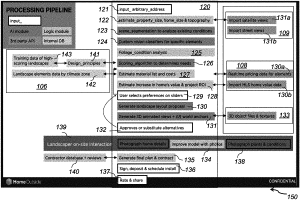
1. A computer-implemented method for generating an online landscape design for a property comprising:
providing a computing system comprising at least a memory storing computer-executable instructions of a landscaping application, and a processor coupled to the memory and wherein said landscaping application comprises a calculator engine, a landscape design engine, and a scoring engine;
providing a user interface (UI);
entering an address for a property via the UI;
importing satellite view data of the property and a street where the property is located from global mapping databases;
calculating property size, topography and house size from the satellite view data using the calculator engine;
performing scene segmentations and analyzing existing conditions of the property via the landscape design engine;
applying vision classifiers for specific landscape elements of the property via the landscape design engine;
analyzing location specific foliage conditions from the satellite view data;
calculating a landscape score of the property by retrieving landscape data from online databases and comparing an existing landscape design of the property to the retrieved landscape data via the scoring engine;
determining property landscape improvements by the scoring engine;
determining materials lists, and calculating quantities, and costs for fulfilling the property landscape improvements via the calculator engine;
entering user preferences for the property landscape improvements via the user interface (UI);
generating an improved landscape design for the property based on the user's preferences and the property landscape improvements of the scoring engine using the landscape design engine;
calculating an improved landscape score of the improved design via the scoring engine and displaying a 3D-image of the property with the improved landscape design and the improved score.
|