| CPC G01C 21/206 (2013.01) [G01C 21/3691 (2013.01); G06T 11/60 (2013.01); H04W 4/024 (2018.02); H04W 4/029 (2018.02); H04W 4/33 (2018.02); G06F 3/0481 (2013.01)] | 7 Claims |
|
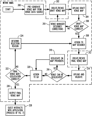
1. A non-transitory computer readable medium storing program code for generating route guidance data for a physical structure, when placed in communication with a processor, the program code causes the processor to perform operations comprising:
storing, in a memory device, physical layout data including a plurality of venue maps associated with one or more spaces of the physical structure, each venue map includes physical layout data for a physical space and, and data representing wayfinding nodes, paths, and landmarks of a physical space, and at least one of the plurality of venue maps having at least one anchor point defined from a Bezier curve;
executing the program code stored in the memory for generating route guidance for the physical structure;
receiving, in real-time from a network, location data identifying a current position within the physical structure;
receiving the physical layout data associated with the physical structure from the memory device; and
generating, in real-time, route guidance data by overlaying onto one or more selected venue maps, the route guidance data showing a travel path between an identified destination and a starting position of a mobile device, the route guidance data identifying, based on the physical layout data, a route event including a change in direction of the route and a unique feature of the physical space.
|