| CPC G06F 18/256 (2023.01) [G06F 18/2411 (2023.01); G06V 20/13 (2022.01)] | 6 Claims |
|
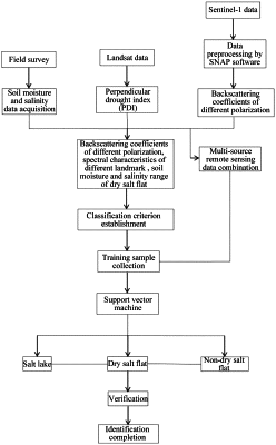
1. A method for identifying a dry salt flat based on sentinel-1 data, comprising:
preprocessing step, for preprocessing the sentinel-1 data with sentinel application platform (SNAP) software to obtain backscattering coefficients;
calculating step, for calculating perpendicular drought indexes (PDIs) with optical image data to obtain an index distribution diagram;
mapping step, for mapping a part of measured data to the backscattering coefficients and the PDIs, extracting corresponding backscattering coefficients, colors, textures and spectrum characteristics of a salt lake and a dry salt flat in different polarizations, and then determining thresholds of ranges of the backscattering coefficients and the PDI of different classification types, wherein the measured data is soil moisture data and salinity data of the dry salt flat and the salt lake acquired in field survey;
establishing step, for selecting one threshold as an initial estimation value from a maximum threshold and a minimum threshold of the PDIs of the salt lake and the dry salt flat, continuously updating the estimation value until a given condition is satisfied, and establishing a classification criterion for the salt lake, the dry salt flat and a non-dry salt flat;
combining step, for performing band combination on the PDIs, the optical images and the sentinel-1 data including vertical transmit/vertical receive (VV) and vertical transmit/horizontal receive (VH) polarization to obtain multi-source combined remote sensing data; and
collecting step, for collecting training samples based on the established classification criterion for the salt lake, the dry salt flat and the non-dry salt flat and in a form of the multi-source combined remote sensing data, and classifying the training samples by utilizing Support Vector Machine (SVM) to obtain a classification result map of the salt lake, the dry salt flat and the non-dry salt flat.
|