| CPC G06Q 50/26 (2013.01) [G06F 3/0484 (2013.01); G06F 16/29 (2019.01); G06F 16/54 (2019.01); G06F 16/5866 (2019.01); G06N 20/00 (2019.01); G06Q 10/20 (2013.01); G06V 20/584 (2022.01); G06V 20/588 (2022.01); G07C 5/008 (2013.01); G08G 1/052 (2013.01); G01C 21/3815 (2020.08); G01C 21/3848 (2020.08); G06Q 10/10 (2013.01); G06Q 40/08 (2013.01); H04L 67/12 (2013.01)] | 18 Claims |
|
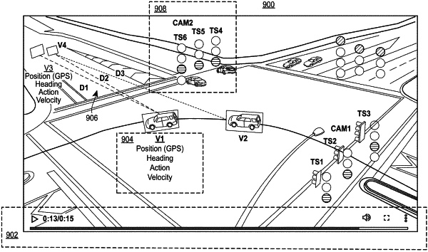
1. A computer-implemented method for providing a graphic user interface to facilitate analyzing vehicle events at a road segment, the method comprising, via one or more local or remote processors, servers, transceivers, and/or sensors:
(A) displaying a graphic user interface (GUI) configured to display at least one of a series of images, the GUI including an image control element interactable to advance forward or backward in time through the series of images;
(B) analyzing a displayed image from the series of images displayed within the GUI to identify a timestamp for the displayed image;
(C) retrieving values for a set of road segment parameters based upon the identified timestamp, such that the values for the set of road segment parameters are relevant-in-time to the displayed image, wherein the set of road segment parameters comprise a parameter collected via one or more vehicle sensors and a parameter collected via one or more infrastructure devices;
(D) dynamically calculating one or more risk indices based upon the set of road segment parameters;
(E) generating a risk score for one or more road segments based upon the one or more risk indices; and
(F) displaying the risk score of the one or more road segments simultaneous to the displaying of the displayed image, such that the risk score, relevant-in-time to the displayed image, is simultaneously viewable with the displayed image.
|