| CPC G01C 21/3841 (2020.08) [G01C 21/1652 (2020.08); G01C 21/3811 (2020.08); G01C 21/3867 (2020.08); G01C 21/3878 (2020.08); G01C 21/3896 (2020.08); G06N 3/02 (2013.01)] | 25 Claims |
|
1. A method comprising:
causing a vehicle to navigate within an environment based at least on a fused map representative of the environment, wherein the fused map is generated, at least, by:
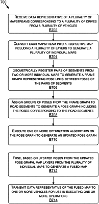
receiving a plurality of mapstreams corresponding to a plurality of drives;
determining segments of two or more mapstreams of the plurality of mapstreams that are within a threshold distance to each other;
generating, based at least on registering the segments from the two or more mapstreams, a frame graph that includes poses and corresponding pose links associated with the two or more mapstreams;
generating, based at least on dividing the frame graph into road segments, a pose graph that includes a first portion of the poses and a first portion of the pose links corresponding to a first position within a first road segment of the road segments and a second portion of the poses and a second portion of the pose links corresponding to a second position within a second road segment of the road segments; and
generating the fused map based at least on fusing data from the two or more mapstreams according to the pose graph.
|