| CPC E21B 44/005 (2013.01) [E21B 7/06 (2013.01); E21B 47/024 (2013.01); G01V 3/26 (2013.01); G01V 3/38 (2013.01)] | 46 Claims |
|
1. A method comprising:
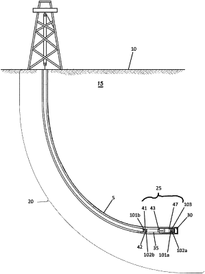
providing a Bottom Hole Assembly (BHA) positioned in a wellbore, the BHA comprising a downhole attitude correction and control system, the downhole correction and control system comprising:
a first sensor set having sensors, wherein the sensors are one or more accelerometers, magnetometers, or gyroscopes;
a second sensor set having sensors, the sensors of the second sensor set positioned further from one or more ferromagnetic components of the drill string than the sensors of the first sensor set, wherein the sensors are one or more accelerometers, magnetometers, or gyroscopes; and
a controller, the controller operatively coupled to and adapted to receive measurements from the first and second sensor sets,
obtaining corrupted data from the first sensor set and reference data from the second sensor set, the corrupted data including along-hole and cross-axis magnetometer and accelerometer measurements;
depth aligning the corrupted sensor data and the reference data;
calculating twist misalignment between the cross-axis magnetometer and accelerometer measurements of the corrupted sensor data to obtain a bias estimate;
calculating an estimated z axis magnetic scale factor and bias of the first sensor set;
calculating a cross-axis magnetic scale factor of the corrupted sensor data;
correcting the corrupted sensor data to form corrected sensor measurements;
calculating an estimated azimuth from the corrected sensor measurements according to:
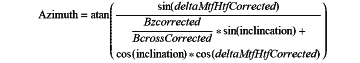 where
deltaMtfHtfCorrected=MTF−HsTF+deltaMtfHtfBiasEstimate
BzCorrected=Bz*BzScale+BzBias
BcrossCorrected=Bcross*BcrossScale; and
transmitting the estimated azimuth to surface via telemetry.
|