| CPC B60W 40/04 (2013.01) [B60W 50/0097 (2013.01); B60W 60/001 (2020.02); G01C 21/3859 (2020.08); B60W 2420/403 (2013.01); B60W 2554/4029 (2020.02); B60W 2554/404 (2020.02)] | 20 Claims |
|
1. A method comprising:
receiving sensor data associated with an environment;
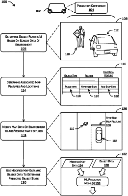
determining, based at least in part on a first subset of the sensor data, a first object at a first physical location in the environment, and a first object type associated with the first object;
determining, based at least in part on a second subset of the sensor data, a second object at a second physical location in the environment, wherein the second object is a dynamic object;
receiving map data associated with the environment;
determining a map feature type associated with the first object, wherein the map feature type is based at least in part on a traffic control directive associated with the first object, and wherein the map feature type represents an object type different from the first object type;
generating modified map data, including combining a new map feature of the map feature type with the map data, at a first map location associated with the first physical location;
determining a representation of the environment, based at least in part on the second subset of the sensor data and the modified map data;
providing the representation as input to a machine learning model;
determining a predicted trajectory of the second object, based at least in part on an output of the machine learning model; and
controlling an autonomous vehicle in the environment, based at least in part on the predicted trajectory of the second object.
|