| CPC G06T 7/0004 (2013.01) [A01B 69/008 (2013.01); B64C 39/02 (2013.01); G06N 3/045 (2023.01); G06N 3/08 (2013.01); G06V 10/82 (2022.01); G06V 10/955 (2022.01); G06V 20/188 (2022.01); A01G 25/16 (2013.01); B64U 2101/30 (2023.01); G06T 2207/10024 (2013.01); G06T 2207/10036 (2013.01); G06T 2207/10048 (2013.01); G06T 2207/20081 (2013.01); G06T 2207/20084 (2013.01); G06T 2207/30188 (2013.01); G06V 10/454 (2022.01); G06V 20/194 (2022.01)] | 18 Claims |
|
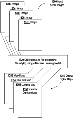
1. A computer-implemented method for generating an improved map of field anomalies using digital images and machine learning models, the method comprising:
obtaining a shapefile that defines boundaries of an agricultural plot;
based on the shapefile, obtaining a plurality of ground based plot images from one or more image capturing devices mounted at a fixed ground location or a ground vehicle at the agricultural plot;
calibrating the plurality of ground based plot images;
stitching the plurality of calibrated ground based plot images into a plot map of the agricultural plot at a plot level;
generating a plot grid;
based on the plot grid and the plot map, defining a plurality of plot tiles for the agricultural plot, each of the plurality of plot tiles including multiple pixels of the plurality of calibrated ground based plot images;
classifying the plurality of plot tiles, using a first machine learning model and a plurality of first image classifiers corresponding to one or more first anomalies, into a set of classified plot images that depicts at least one anomaly, wherein each of the plurality of plot tiles is classified into classifications at least corresponding to a crop, a weed, trees, and inter-row damage;
determining, for each image in the set of classified plot images, a probability that the image is correctly classified, and further comparing the probability to an acceptable probability;
based on the set of classified plot images, generating a plot anomaly map for the agricultural plot; and
transmitting the plot anomaly map to one or more controllers that control one or more agricultural machines to perform agricultural functions on the agricultural plot.
|