| CPC G06T 11/00 (2013.01) [G01C 11/025 (2013.01); G01C 11/08 (2013.01); G06F 3/041 (2013.01); G06T 7/70 (2017.01); G06V 10/74 (2022.01); G06T 2207/10028 (2013.01); G06T 2207/20104 (2013.01)] | 23 Claims |
|
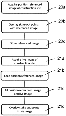
1. A method for displaying desired positions in a live image of a construction site, comprising:
recording at least one position-referenced image of the construction site,
linking at least one desired position to the position-referenced image, storing the position-referenced image together with desired position linkage in an electronic memory,
recording a live image of the construction site, wherein the live image and the position-referenced image at least partially represent an identical detail of the construction site,
retrieving the stored position-referenced image from the memory,
fitting the position-referenced image with the live image, so that the desired position linked to the position-referenced image can be overlaid in a position-faithful manner on the live image,
position-faithful display of the desired position as a graphic marking in the live image.
|