| CPC G01V 20/00 (2024.01) [G01V 11/002 (2013.01); G06N 20/20 (2019.01)] | 18 Claims |
|
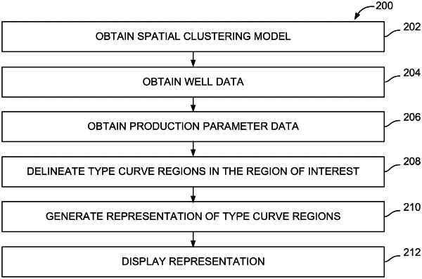
1. A computer-implemented method for identifying type curve regions as a function of position in a region of interest, the computer-implemented method being implemented in a computer system that includes a physical computer processor, a non-transitory storage medium, and a display, the computer-implemented method comprising:
obtaining a spatial clustering model from the non-transitory storage medium;
obtaining well data from the non-transitory storage medium, wherein the well data includes well locations in the region of interest and corresponding productivity for the well locations;
obtaining production parameter data from the non-transitory storage medium, wherein the production parameter data includes production parameter values characterizing subsurface production features that affect reservoir productivity in the region of interest;
delineating, with the physical computer processor, each of the type curve regions in the region of interest by applying the spatial clustering model to the well data and the production parameter data, evaluating differences in types of productivity values, and identifying a target type curve region with greater distinction in mean productivity values relative to a neighboring type curve region and minimal variation in productivity values within the target type curve region;
generating, with the physical computer processor, a representation of the type curve regions as the function of the position in the region of interest using visual effects to depict geographic boundaries outlining at least some of the type curve regions delineated using the spatial clustering model; and
displaying the representation via the display.
|