| CPC B60W 40/105 (2013.01) [G01C 21/32 (2013.01); B60W 2420/408 (2024.01); B60W 2520/10 (2013.01); B60W 2520/14 (2013.01); B60W 2556/40 (2020.02)] | 21 Claims |
|
1. A computer-implemented method for determining at least one of position data or motion data of a vehicle, wherein the computer-implemented method comprises:
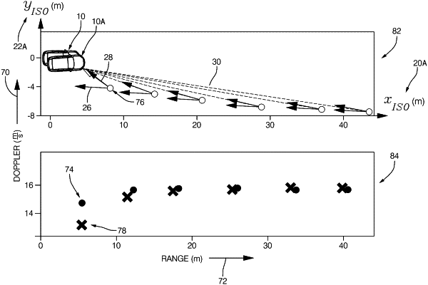
capturing at least one scan from a radar or LiDAR sensor, the radar or LiDAR sensor having a single antenna such that a plurality of sensor data samples reflected by at least one object in a vicinity of the vehicle are in a single-dimensional spatial sensor data representation having two components, wherein the two components comprising the single-dimensional spatial sensor data representation being range and Doppler, respectively, the range representing a distance between the radar or LiDAR sensor and the at least one object, and the Doppler representing a rate of change of a radial distance between the radar or LiDAR sensor and the at least one object over time;
determining, from a database, a predefined map, wherein the predefined map represents the vicinity of the vehicle and comprises at least one element representing a static landmark, wherein the at least one element is in a multi-dimensional spatial map data representation comprising a plurality of coordinates, wherein the plurality of coordinates represent position information of the static landmark;
determining a transformed map by transforming the at least one element of the predefined map from the multi-dimensional spatial map data representation into the single-dimensional spatial sensor data representation resulting in each element of the at least one element of the predefined map being represented on the transformed map by a corresponding range and a corresponding Doppler;
matching at least a subset of the at least one object to the at least one element of the transformed map based on respective ranges and respective Dopplers, wherein the matching is carried out in dependence on at least one influence parameter for controlling an influence of the plurality of sensor data samples on the matching; and
determining the at least one of the position data or the motion data of the vehicle based on the matching.
|