| CPC B25J 9/1666 (2013.01) [G05D 1/0088 (2013.01); G05D 1/0214 (2013.01); G05D 1/024 (2013.01); G05D 1/0274 (2013.01); G08G 1/00 (2013.01)] | 20 Claims |
|
1. A computer-implemented method comprising:
receiving, by a computer system of an autonomous mobile robot, instructions for completing a particular task within a facility;
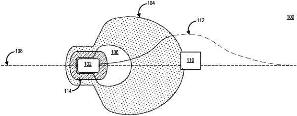
generating, by the computer system, a local travel path for navigating the facility to complete the particular task at a certain speed based at least in part on generating a first bounded area of a first size around the autonomous mobile robot using first sensor data from a first set of sensors associated with the autonomous mobile robot and generating a second bounded area of a second size around the autonomous mobile robot based at least in part on speed information from one or more propulsion components of the autonomous mobile robot, the second bounded area associated with second sensor data from a second set of sensors associated with the autonomous mobile robot, the first set of sensors configured to detect an object within the first bounded area and the second set of sensors configured to detect the object within the second bounded area;
detecting, by the computer system, the object within the local travel path based at least in part on the first sensor data identifying the object within the first bounded area;
identifying, by the computer system, dimensional measurements for a space around the object within the first bounded area based at least in part on the first sensor data;
receiving, by the computer system, an indication of a fiduciary marking within a certain distance of the autonomous mobile robot, the fiduciary marking associated with a continuous wall of the facility; and
generating, by the computer system, a new local travel path and an updated speed for the autonomous mobile robot to utilize to navigate the facility based at least on the dimensional measurements, the indication of the fiduciary marking, and an updated second size of the second bounded area, the updated second size of the second bounded area generated by at least filtering a portion of the second sensor data based on the indication of the fiduciary marking.
|