| CPC A61B 5/066 (2013.01) [A61B 1/2676 (2013.01); A61B 5/062 (2013.01); A61B 5/7253 (2013.01); A61B 6/032 (2013.01); A61B 34/20 (2016.02); G06T 7/30 (2017.01); A61B 6/504 (2013.01); A61B 6/5247 (2013.01); A61B 6/547 (2013.01); A61B 2017/00809 (2013.01); A61B 2034/105 (2016.02); A61B 2034/2051 (2016.02); A61B 2034/2072 (2016.02); A61B 2090/363 (2016.02); A61B 2090/364 (2016.02); A61B 2090/3925 (2016.02)] | 18 Claims |
|
1. A system comprising:
a location sensor capable of being navigated within a luminal network inside a patient's body;
an electromagnetic field generator configured to detect a location of the location sensor as it is navigated within the luminal network;
a computing device including a processor and a memory; and
an application, stored in the memory and executed by the processor, which when executed, causes the computing device to:
during a planning phase:
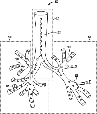
receive a 3D model of the luminal network, the 3D model being generated from computed tomographic (CT) images of the luminal network, the 3D model corresponding to a CT coordinate space;
generate a navigation plan; and
select, at predetermined distance intervals, a plurality of reference points within the 3D model of the luminal network, the reference points being along a center of the luminal network of the 3D model;
during a registration phase:
receive a plurality of survey points within the luminal network, the plurality of survey points corresponding to a body coordinate space and being based on locations of the location sensor while the location sensor is navigated within the luminal network;
correlate the plurality of survey points with the plurality of reference points to determine pairs of correlated reference points and survey points; and
derive a thin plate splines (TPS) transformation that maps the body coordinate space to the CT coordinate space based on the pairs of correlated reference points and survey points by interpolating additional points in the body coordinate space and the CT coordinate space based on an inverse multi-rigid registration, yielding a derived TPS transformation;
during a navigation phase different from the registration phase:
receive a further survey point from the location sensor, which is navigated according to the navigation plan;
determine a location of the location sensor in the CT coordinate space by determining a point in the 3D model corresponding to the further survey point by applying the derived TPS transformation to the further survey point; and
update the derived TPS transformation based on a plurality of second additional correlated points interpolated from the inverse multi-rigid registration performed on the further survey point while navigation is in progress.
|