| CPC G08G 1/096791 (2013.01) [G01C 21/3492 (2013.01); G01C 21/3822 (2020.08); G08G 1/0112 (2013.01); G08G 1/0133 (2013.01); G08G 1/0141 (2013.01); G08G 1/096716 (2013.01); G08G 1/096741 (2013.01); G08G 1/096775 (2013.01); G08G 1/096844 (2013.01); G08G 1/0969 (2013.01); G08G 1/20 (2013.01); G08G 1/205 (2013.01)] | 12 Claims |
|
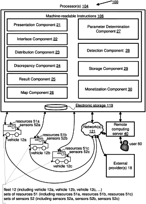
12. A method for using data-processing resources carried by multiple vehicles to modify map data, including a first vehicle located near first surroundings and a second vehicle located near second surroundings, the method comprising:
maintaining a real-time map of a geographical area, wherein the real-time map includes information related to one or more location-specific features of the first surroundings and the second surroundings;
receiving, from a first transceiver carried by the first vehicle, first discrepancy information, wherein the first discrepancy information reflects a first detected discrepancy between the real-time map and the first surroundings of the first vehicle that have been detected;
receiving, from a second transceiver carried by the second vehicle, second discrepancy information, wherein the second discrepancy information reflects a second detected discrepancy between the real-time map and the second surroundings of the second vehicle that have been detected;
determining whether the first detected discrepancy corresponds to the second detected discrepancy; and
responsive to a threshold number of more than one different vehicles having detected corresponding discrepancies, modifying the real-time map, wherein a modification of the real-time map is based on one or both of the received first discrepancy information and the received second discrepancy information.
|