| CPC G08G 1/0125 (2013.01) [G08G 1/167 (2013.01)] | 3 Claims |
|
1. A mapping method for right-turn conflict warning lines at urban road intersections, wherein one or more processors are configured to implement the following steps:
(1) receiving, by the one or more processors, video data of a road intersection through a drone traffic flow video detection device, wherein the road intersection comprises large vehicles traffic;
(2) extracting, by the one or more processors, from the video data of the road intersection obtained in step (1), to obtain:
rear wheel trajectory data of a right-turn of the large vehicles at the road intersection, and obtaining a rear wheel trajectory data group, wherein obtaining, by the one or more processors, the rear wheel trajectory data of the right-turn of the large vehicles described in step (2), comprises the steps of:
(2.1) selecting, by the one or more processors:
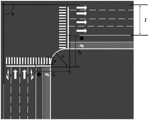
a corner of a rightmost lane as an origin of coordinates;
two feature points with a known distance; and
the distance between the two feature points as a feature length;
(2.2) using, by the one or more processors, a rear wheel area of the large vehicle which is turning right in the video as a feature area for identification and tracking, and then calculating, by the one or more processors, a center of the wheel area as a wheel center, and using, by the one or more processors, a wheel center coordinate tracking result of each frame as a motion trajectory of the vehicle wheel center; and
(2.3) collecting, by the one or more processors, a trajectory y=h(x) of monitoring points within a plurality of frames, wherein x is a coordinate in a horizontal direction of a rear wheel trajectory of the large vehicle, wherein y is a coordinate in a vertical direction of the rear wheel trajectory of the large vehicle, and determining, by the one or more processors, the coordinate (x, y) of each frame of the vehicle running on a curve of the road intersection by comparing a characteristic length;
(3) fitting, by the one or more processors, an outermost rear wheel trajectory curve and an innermost rear wheel trajectory curve, according to the rear wheel trajectory data group of the right-turn of the large vehicles obtained in step (2);
a fitting method of the outermost rear wheel trajectory curve and the innermost rear wheel trajectory curve, implemented by the one or more processors, is as follows:
fitting, by the one or more processors, outer coordinate points of the rear wheel trajectory data group to obtain the outermost rear wheel trajectory curve y=f(xoutermost):
y=A2outermost+(A1outermost−A2outermost)·[1+(x/x0outermost)poutermost]
among them, A1outermost, A2outermost, X0outermost and Poutermost are influence parameters of the outer rear wheel trajectory curve;
(4) determining, by the one or more processors, a relative position of the outermost rear wheel trajectory curve, the innermost rear wheel trajectory curve, and a zebra crossing on a premise that a right-turn conflict area does not exceed an edge of the zebra crossing, and determining, by the one or more processors, the right-turn conflict area of the large vehicles: the area between the inner rear wheel trajectory curve, the outer rear wheel trajectory curve and the zebra crossing;
(5) obtaining, by the one or more processors, dynamic index data and static index data of the road intersection;
the dynamic index comprises an average body length of the of large vehicles taking the right turn at the road intersection, an average speed of the large vehicles taking the right turn at the road intersection, and a traffic flow at the road intersection;
the static index comprises a one-way road width of the road intersection, an intersection angle of the road intersection, width of the zebra crossing of an entrance of the road intersection, a design turning radius of the road intersection, a distance from a right-turn lane endpoint to an exit stop line of the road intersection, a distance from the entrance of the road intersection to a stop line intersection;
(6) constructing, by the one or more processors, a dynamic model of the right-turn conflict area of the large vehicles by using a regression model;
specifically, establishing, by the one or more processors, a multiple linear regression model by using the dynamic and the static index data in step (5) as independent variables, and influence parameters of the outermost rear wheel trajectory curve and the innermost rear wheel trajectory curve as dependent variables; analyzing, by the one or more processors, the multiple linear regression model to obtain a relationship between the influence parameters of the outermost rear wheel trajectory curve and the innermost rear wheel trajectory curve and the dynamic index and the static index, so as to obtain the dynamic model of the right-turn conflict area of the large vehicles;
the multiple linear regression model, implemented by the one or more processors, is as follows:
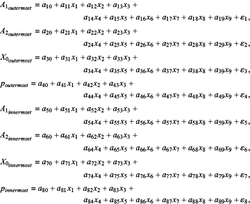 wherein x1 is the average body length of the large vehicles taking the right turn at the road intersection, x2 is the average speed of the large vehicles turning right at the road intersection, x3 is the one-way road width of the road intersection, x4 is a size of the intersection angle of the road intersection, x5 is the width of the zebra crossing of the road intersection, x6 is the traffic flow at the road intersection, x7 is the design turning radius of the road intersection, x8 is the distance from the right-turn lane endpoint to the exit stop line of the road intersection, x9 is the distance from the entrance of the road intersection to the stop line intersection;
(7) obtaining, by the one or more processors, the dynamic index data and the static index data of the right-turn conflict warning line at the road intersections, and inputting, by the one or more processors, the dynamic index data and the static index data into the dynamic model of the right-turn conflict area of the large vehicles in step (6), obtaining, by the one or more processors, the outermost rear wheel trajectory curve and the innermost rear wheel trajectory curve of the road intersection, and drawing, by the one or more processors, the right-turn conflict area warning line along the outermost rear wheel trajectory curve, the innermost rear wheel trajectory curve and the zebra crossing.
|