| CPC G06T 7/507 (2017.01) [G06T 3/4038 (2013.01); G06T 7/521 (2017.01); G06V 20/176 (2022.01); G06V 40/103 (2022.01); G06T 2207/10032 (2013.01); G06T 2207/30181 (2013.01); G06V 2201/07 (2022.01)] | 20 Claims |
|
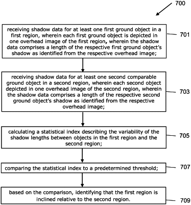
1. A computer-implemented method for identifying region incline from at least one temporally-compatible overhead image, the method comprising:
receiving shadow data for at least one first ground object in a first region, wherein each first ground object is depicted in one overhead image of the first region, wherein the shadow data comprises a length of the respective first ground object as identified from the respective overhead image;
receiving shadow data for at least one second comparable ground object in a second region, wherein each second ground object is depicted in one overhead image of the second region, wherein the shadow data comprises a length of the respective second ground object as identified from the respective overhead image;
calculating a statistical measure describing the variability of the shadow lengths between objects in the first region and the second region;
comparing the statistical measure to a predetermined threshold; and
based on the comparison, identifying that the first region is inclined relative to the_second region.
|