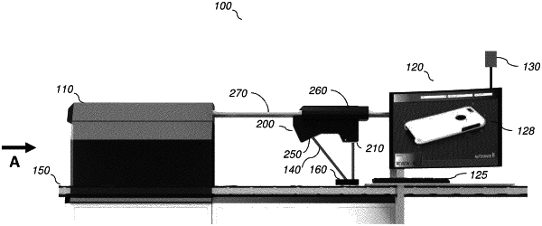
Automated 360-degree dense point object inspection
Bruce A. Link, Rochester, NY (US); Robert W. Johnson, Rochester, NY (US); Jose Zvietcovich Zegarra, Rochester, NY (US); Peter O. Stubler, Rochester, NY (US); Mark Barton, Rochester, NY (US); Frank R. Brockler, Rochester, NY (US); Michael S. Axman, Rochester, NY (US); Madirakshi Das, Rochester, NY (US); and Gabor J. Ferencz, Jr., Rochester, NY (US)
Assigned to KODAK ALARIS INC., Rochester, NY (US)
Filed by KODAK ALARIS INC., Rochester, NY (US)
Filed on Jun. 1, 2021, as Appl. No. 17/335,882.
Application 17/335,882 is a continuation of application No. 16/401,890, filed on May 2, 2019, granted, now 11,042,146.
Application 16/401,890 is a continuation in part of application No. 16/033,858, filed on Jul. 12, 2018, granted, now 11,049,236.
Claims priority of provisional application 62/587,806, filed on Nov. 17, 2017.
Prior Publication US 2021/0286339 A1, Sep. 16, 2021
1. An object inspection system, the system comprising: a scanning unit configured to scan a calibration target to obtain a point cloud representing the target; and a processor configured to receive the point cloud representing the target from the scanning unit, and to: tessellate the point cloud into one or more tiles containing a plurality of points of the point cloud; for each of the one or more tiles, fit a plane model to the points contained in the tile, wherein the plane model includes value of a three-dimensional vector normal to the surface of the plane and the distance of the plane from a coordinate system reference point; add the normal vectors from each of the one or more tiles and calculate the average of the collection of normal vectors; use average normal vector orientation to define a reference plane outside the point cloud and calculate each cloud point to reference plane; and use a histogram to find local maximums, and create a group of points each with a distance to the defined reference plane that falls within a tolerance threshold to the local maximum; and monitor the performance of the scanning unit.