| CPC H04W 4/021 (2013.01) [G06F 16/29 (2019.01); H04L 67/133 (2022.05); H04L 67/51 (2022.05); H04W 4/029 (2018.02); H04Q 11/0067 (2013.01)] | 18 Claims |
|
1. A method for operating a network, the method comprising:
obtaining geolocation coordinates of an address received at a computing device, the received address corresponding to a potential termination site for a communications network;
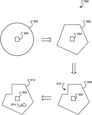
obtaining, based on the geolocation coordinates and from a database in communication with the computing device, a service area polygon comprising a plurality of geographic boundaries defining an area of an available network service and which contains the geolocation coordinates of the potential termination site;
altering at least one of the plurality of geographic boundaries based on a physical barrier obtained from a topographical map comprising a geographic location of network equipment;
correlating, in a service map of a geographic area, the service area polygon with the geolocation coordinates of the potential termination site, wherein the correlation corresponds to an availability of the network service to the potential termination site; and
displaying the correlation of the service area polygon with the geolocation coordinates of the potential termination site in the service map.
|