| CPC G06V 20/588 (2022.01) [G06T 7/0002 (2013.01); G06V 20/58 (2022.01); G06T 2207/10016 (2013.01); G06T 2207/10024 (2013.01); G06T 2207/30256 (2013.01)] | 14 Claims |

|
1. A method comprising:
capturing, by a camera on a travelling vehicle, a plurality of road images of a road;
selecting, by processor circuitry, a plurality of diagnostic images from the plurality of road images;
determining, by the processor circuitry, a condition level of a diagnostic target feature in each of two or more of the plurality of selected diagnostic images; and
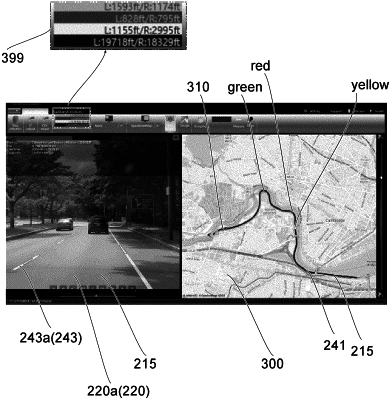
visualizing:
one diagnostic image of the plurality of selected diagnostic images, the one diagnostic image showing one diagnostic target feature of the plurality of the diagnostic target features; and
a map showing the road and showing the condition levels along the road,
wherein the method further comprises detecting a trigger feature in the plurality of road images, and the selecting of the plurality of diagnostic images includes selecting based on the detected trigger feature, and
wherein the selecting of the plurality of diagnostic images includes:
selecting, from the road images, a plurality of first diagnostic images that correspond to images that are captured at a first distance intervals along the road wherein the selecting of the plurality of the first diagnostic images is based on the trigger feature; and
selecting, from the road images, a plurality of second diagnostic images that correspond to images that are captured at second distance intervals along the road, wherein the selecting of the second diagnostic images is not based on the trigger feature, wherein each of the second distance intervals is greater than each of the first distance intervals.
|