| CPC G06N 5/04 (2013.01) [G06F 16/22 (2019.01); G06F 16/24578 (2019.01); G06F 16/29 (2019.01); G06F 16/9537 (2019.01); G06F 40/103 (2020.01); G06N 3/04 (2013.01); G06N 3/088 (2013.01)] | 20 Claims |
|
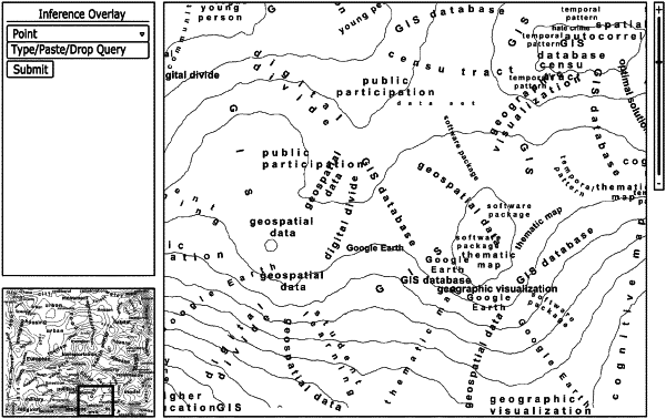
1. A method of constructing a base map, the method comprising:
processing data items to create modified data items;
processing the modified data item to create a topic model usable data format to form a topic model, the topic model comprising a plurality of topics;
processing the topic model into a self-organizing map (SOM) including a plurality of neurons to form a geometric data structure having a geometric shape that represents each of the neurons from the SOM, wherein each of the neurons includes attribute data including a weight for each of the topics in the topic model;
calculating a measure of spatial autocorrelation for each of the topics in the topic model;
identifying at least some of the topics as stop topics based on the measure of spatial autocorrelation;
removing the stop topics from the modified data items; and
providing the geometric data structure into a geographic information system (GIS) to form a base map including the neurons represented with the geometric shape,
wherein the neurons in the base map are clustered into polygons based on the attribute data, and
wherein the base map is scale dependent such that an appearance of symbolized layers and labels depends on a zoom level of the base map.
|