| CPC G05D 1/0246 (2013.01) [G01C 21/3848 (2020.08); G05D 1/0088 (2013.01); G05D 1/0212 (2013.01); G05D 1/0223 (2013.01); G05D 1/0251 (2013.01); G05D 1/0274 (2013.01); G06Q 10/0833 (2013.01); G06T 7/579 (2017.01); G06T 7/73 (2017.01); G06T 7/97 (2017.01); G05D 1/024 (2013.01); G05D 1/0255 (2013.01); G05D 1/027 (2013.01); G05D 1/0272 (2013.01); G05D 1/0278 (2013.01); G05D 2201/0213 (2013.01); G05D 2201/0216 (2013.01); G06T 2207/10004 (2013.01); G06T 2207/10016 (2013.01); G06T 2207/20212 (2013.01); G06T 2207/30244 (2013.01); G06T 2207/30252 (2013.01)] | 23 Claims |
|
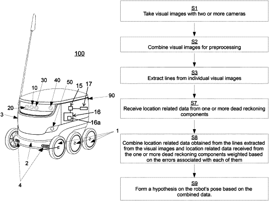
1. A mapping method performed by a processor for generating a map of an area in which a mobile robot travels, comprising:
(a) extracting features from visual images with at least one processing component;
(b) determining which of the extracted features are associated with transitory physical objects and discarding those features associated with transitory physical objects, and detecting permanent physical objects in the visual images based at least in part on the remaining extracted features;
(c) receiving location-related data from one or more sensors;
(d) combining the location-related data with data from the visual images; and
(e) generating map data based on the detected permanent physical objects and received location-related data.
|