| CPC G01W 1/10 (2013.01) [G01W 1/02 (2013.01); G08G 5/0065 (2013.01); G08G 5/0091 (2013.01); G08G 5/025 (2013.01); G01W 1/00 (2013.01); G01W 2001/003 (2013.01); G01W 2001/006 (2013.01); G01W 2201/00 (2013.01); G01W 2203/00 (2013.01); G06N 5/00 (2013.01); G06N 20/00 (2019.01); H04W 84/005 (2013.01); Y02A 90/10 (2018.01)] | 21 Claims |
|
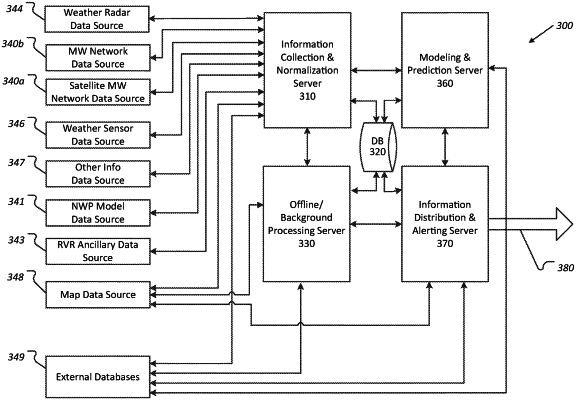
1. A method of determining localized weather data by processing microwave receiver detection datums detected by at least one earth station microwave radio receiver, the microwave receiver detection datums representing signal strength and/or attenuation of microwaves transmitted over satellite microwave paths, the method-comprising performing, with at least one processor, operations comprising:
predefining pro forma satellite microwave paths between earth station endpoints and endpoints representing proforma satellite locations outside of earth's atmosphere;
pre-calculating at least one transform for each predefined pro forma satellite microwave path, including defining at least one satellite link segment based on a point of intersection of the predefined pro forma satellite microwave path with at least one stratum and pre-calculating a transform for the at least one satellite link segment, the pre-calculated at least one transform predefining virtual microwave signal path attributes including (a) satellite microwave path geometry, and (b) at least one signal attenuation over the satellite microwave path geometry; and
processing datums detected by at least one ground station radio receiver, representing signal strength and/or attenuation of microwaves transmitted by a satellite, by performing operations comprising:
associating the radio receiver-detected datums with at least one predefined pro forma satellite microwave path; and
using the pre-calculated at least one transform—to project the at least one satellite link segment onto at least one projection and to transform plural detected radio receiver-detected datums into attenuation-based geographically localized weather data corresponding to geographical regions of the at least one projection.
|