| CPC B66C 13/46 (2013.01) [G01S 17/89 (2013.01); G06T 7/13 (2017.01); G06V 10/443 (2022.01); G06T 2207/10028 (2013.01)] | 7 Claims |
|
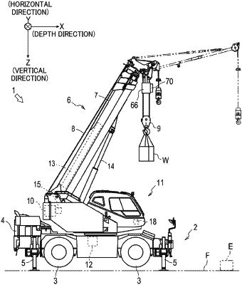
1. A guide display device of a crane, comprising:
a data processing section configured to calculate a representative point for each grid cell by using point group data acquired with a laser scanner by scanning a lifting cargo, a ground surface and a ground object from above the lifting cargo, create a three-dimensional map based on the representative point, and update the three-dimensional map when a representative point calculated anew and an existing representative point are different from each other,
wherein the data processing section detects an edge of the ground object based on a result of image processing of image data of the lifting cargo, the ground surface and the ground object captured with a camera from above the lifting cargo, recognizes the ground object based on the edge, accumulates, for predetermined frames prior to a time point of capturing the image data, the point group data that is in a nearby range of the edge of the ground object and is recognized to be the ground surface, and generates the three-dimensional map of the ground object whose edge is recognized based on the point group data that is accumulated.
|