| CPC B64C 39/024 (2013.01) [G05D 1/0094 (2013.01); G05D 1/104 (2013.01); B64U 10/13 (2023.01); B64U 2101/30 (2023.01); B64U 2101/32 (2023.01); B64U 2201/10 (2023.01)] | 20 Claims |
|
1. A method comprising:
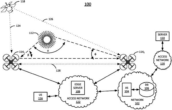
determining, by a processing system of a first unmanned aerial vehicle including at least one processor, current coordinates and a current elevation setting of the first unmanned aerial vehicle, where the first unmanned aerial vehicle is to be deployed to a candidate location for a microwave radio dish;
receiving, by the processing system, expected coordinates and an expected elevation setting of a second unmanned aerial vehicle that is deployed to a location of an existing cellular base station;
calculating, by the processing system, an angle necessary to direct a flash of light from the first unmanned aerial vehicle toward the expected coordinates and expected elevation setting of the second unmanned aerial vehicle;
adjusting, by the processing system, a current angle of an optical system of the first unmanned aerial vehicle to match the angle that is calculated;
controlling, by the processing system, the optical system to generate the flash of light once the current angle of the optical system matches the angle that is calculated, wherein the flash of light serves as a trigger that causes the second unmanned aerial vehicle to capture an image of the flash of light; and
sending, by the processing system in response to a signal from the second unmanned aerial vehicle that the second unmanned aerial vehicle has captured the image of the flash of light, a dataset to a centralized computing device, wherein the dataset includes at least an elevation setting of the first unmanned aerial vehicle at a time of capture of the image of the flash of light by the second unmanned aerial vehicle.
|