| CPC B60W 60/001 (2020.02) [B60W 30/143 (2013.01); B60W 30/16 (2013.01); G01C 21/32 (2013.01); G01C 21/3407 (2013.01); G01C 21/3859 (2020.08); G01C 21/3885 (2020.08); G08G 1/22 (2013.01); B60W 2420/40 (2013.01); B60W 2420/403 (2013.01); B60W 2420/408 (2024.01); B60W 2552/53 (2020.02); B60W 2554/20 (2020.02)] | 20 Claims |
|
1. A system, comprising:
a lead autonomous vehicle comprising at least one vehicle sensor located on the lead autonomous vehicle and configured to observe a first field-of-view comprising a region in front of the lead autonomous vehicle;
one or more following autonomous vehicles, different from the lead autonomous vehicle, wherein:
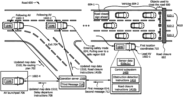
the lead autonomous vehicle is on a particular road heading toward a destination using a first routing plan and map data previously received from an operation server;
the one or more following autonomous vehicles are on the particular road behind the lead autonomous vehicle; and
the lead autonomous vehicle and the one or more following autonomous vehicles are communicatively coupled with the operation server;
a first control subsystem, associated with the lead autonomous vehicle, communicatively coupled with the lead autonomous vehicle, the one or more following autonomous vehicles, and the operation server, the first control subsystem comprising a first processor configured to:
receive sensor data from the at least one vehicle sensor of the lead autonomous vehicle, wherein the sensor data comprises location coordinates of any object on the particular road within the first field-of-view of the lead autonomous vehicle;
compare the sensor data with a first portion of the map data, wherein the first portion of the map data comprises location coordinates of expected objects on the particular road within the first field-of-view of the lead autonomous vehicle;
based at least in part upon comparing the sensor data with the first portion of the map data, determine whether a structural change in the particular road is detected by identifying one or more objects in the sensor data that correspond to the structural change and that are not among the expected objects in the map data, wherein the structural change comprises a particular structural change associated with an object that is not behaving as expected from the map data;
in response to a determination that the structural change is detected in the particular road:
update driving instructions of the lead autonomous vehicle to navigate through the structural change using driving instructions related to the structural change;
send a first message to the operation server indicating that the structural change is detected; and
the operation server comprising a second processor configured to:
based at least in part upon the first message, update the first portion of the map data, reflecting the structural change;
send the updated map data to the one or more following autonomous vehicles,
for a following autonomous vehicle from among the one or more following autonomous vehicle:
determine a location of the following autonomous vehicle;
determine whether the structural change causes a first driving time including navigating through the structural change to become more than second driving times associated with alternative routes that reach the destination based at least in part upon the determined location of the following autonomous vehicle;
in response to determining that the structural change causes the first driving time to become more than the second driving times:
identify a particular alternative route that is associated with less driving time compared to the first driving time; and
send a re-routing plan to the following autonomous vehicle, wherein the re-routing plan comprises instructions to re-route to the particular alternative route, wherein in response to receiving the re-routing plan, the following autonomous vehicle is autonomously navigated according to the re-routing plan;
access traffic data that indicate traffic along each of the alternative routes;
determine whether each of the first driving time and the second driving times is more than a threshold driving time; and
in response to determining that each of the first driving time and the second driving times is more than the threshold driving time, send a pulling over instructions to the following autonomous vehicle, wherein the following autonomous vehicle is autonomously navigated according to the pulling over instructions.
|