| CPC G06T 7/97 (2017.01) [G06F 16/535 (2019.01); G06F 16/55 (2019.01); G06T 3/12 (2024.01); G06T 3/40 (2013.01)] | 11 Claims |

|
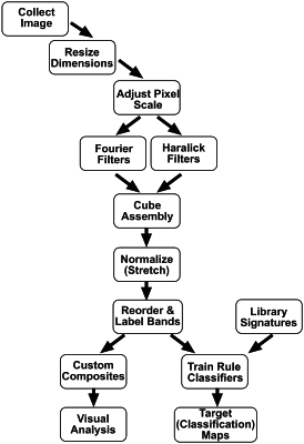
1. A method for identifying terrain, terrain activity and/or materials, said method comprising:
a) comparing one or more panchromatic images that have been processed as follows:
(i) resizing dimensions of said one or more panchromatic images to establish a scale for each panchromatic image;
(ii) adjusting a pixel scale of said one or more panchromatic images;
(iii) filtering at least one of said one or more panchromatic images through a Fourier frequency isolation filter and/or a statistically derived Haralick texture measurement filter, said filters being tuned to different spatial windows and frequencies, said filtering generating a set of multiple images;
(iv) combining the set of multiple images to form a multiband texture cube assembly for the set of images, the multiband texture cube assembly having multiple new bands;
(v) normalizing the multiband texture cube assembly;
(vi) reordering and labeling the multiple new bands to match a library or reference database format or a band sequence;
with an image database that comprises images that have been processed in the same manner as said one or more panchromatic images;
b) using said comparison to identify one or more terrains, terrain activities and/or materials contained in one or more images of said panchromatic images.
|