| CPC G01S 19/40 (2013.01) [G01C 21/32 (2013.01); G01S 17/89 (2013.01); G06T 17/05 (2013.01); G06V 10/74 (2022.01); G01S 19/07 (2013.01); G01S 19/485 (2020.05)] | 10 Claims |
|
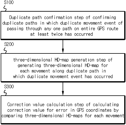
1. A method of aiding autonomous driving through GPS (Global Positioning System) error correction, the method comprising:
a duplicate path confirmation step of confirming a duplicate path in passing through an entire GPS route of a predetermined area through which a vehicle drives to generate the entire GPS route, wherein the duplicate path is a segment of the entire GPS route through which the vehicle moves at least twice and is detected via detecting one or more duplicate movement events during each of which the vehicle passed through the segment at least twice, wherein the entire GPS route comprises a plurality of GPS coordinates along the entire GPS route;
a three-dimensional HD-map (High Definition map) generation step of generating a three-dimensional HD-map for each of the one or more duplicate movement events along the duplicate path based on three-dimensional point cloud data acquired from sensors including LiDAR (Light Detection and Ranging) and IMU (Inertial Measurement Unit), wherein the three-dimensional HD-map comprises data representing contour lines for elevation in addition to X-Y coordinates representing locations; and
a correction value calculation step of calculating a correction value for an error in the plurality of GPS coordinates along the duplicate path by comparing, for each of the one or more duplicate movement events along the duplicate path, data in the three-dimensional HD-map corresponding to each of the one or more duplicate movement events along the duplicate path, with GPS coordinates in the entire GPS route corresponding to each of the one or more duplicate movement events along the duplicate path, incorporating the correction value for the error in the GPS coordinates along the duplicate path into the entire GPS route of the predetermined area to form a corrected GPS route; and
an application step of applying the corrected GPS route in an autonomous driving.
|