| CPC E21B 25/00 (2013.01) [E21B 47/00 (2013.01); E21B 47/0025 (2020.05); E21B 47/022 (2013.01); G01V 99/005 (2013.01); G06T 17/05 (2013.01)] | 26 Claims |
|
1. A method, comprising:
executing, via a processor, instructions stored on memory, to perform:
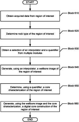
obtaining acquired data for a region of interest, wherein the acquired data is obtained from samples captured at discrete locations along a sidewall of a wellbore;
determining a rock type of the region of interest;
obtaining a selection of a plurality of modules based on the rock type;
generating, using the acquired data and an interpolator from the plurality of modules, a wellbore image of the region of interest, wherein the interpolator generates interpolated data for gaps in data acquisition between the discrete locations in the acquired data in the wellbore image;
generating a slab image of the region of interest using:
the acquired data including the samples captured at the discrete locations along the sidewall of the wellbore, and
the interpolator from the plurality of modules, wherein the interpolator uses the interpolated data to generate the slab image indicating a slice transecting the interpolated data at two points of the slab image;
determining, using a quantifier from the plurality of modules, a core characterization of the region of interest, wherein the core characterization describes an integration of a plurality of wellbore data types;
using the quantifier to generate quantification data from the acquired data, the wellbore image, and the slab image;
performing a plurality of analyses using the quantification data to define the plurality of wellbore data types, wherein the plurality of analyses includes at least one of textural analysis, grain size sorting, heterogeneity analysis or lithology analysis;
generating, using the core characterization, the wellbore image, the slab image, and
the plurality of analyses, a digital core construction of the region of interest, wherein the digital core construction describes a plurality of subterranean formation properties of the region of interest, and the digital core construction comprises a substantially 360 degree image of a wellbore surface, as a function of depth in a well, of at least a portion of the region of interest;
using the digital core construction of the region of interest to
select locations to obtain a large-volume sidewall core sample of the wellbore by drilling into the sidewall of the wellbore to acquire a portion of a formation of the region of interest; and
sample the large-volume sidewall core sample from the portion of the formation of the region of interest, wherein the large-volume sidewall core sample has a size with a minimum dimension of at least 1.5 inches in diameter and length; and
validating and calibrating both the core characterization and the digital core construction using physical core data from analysis of the large-volume sidewall core sample by using the physical core data to validate and calibrate at least one of the acquired data, the interpolated data for the gaps in data acquisition between the discrete locations in the acquired data, the slab image, or the quantification data.
|