| CPC F41G 9/002 (2013.01) | 14 Claims |
|
1. A terrain-referenced navigation system for an aircraft, the system comprising:
a memory containing a stored digital terrain map comprising a plurality of map posts of terrain elevation;
a position calculation processing unit that:
receives input from a radar altimeter; and
matches radar altimeter measurements of terrain already traversed with the stored digital terrain map in order to calculate aircraft position relative to the stored digital terrain map to determine a terrain-referenced aircraft position;
a fall line calculation processing unit that:
receives the terrain-referenced aircraft position; and
calculates a fall line for a projectile starting from the terrain-referenced aircraft position as a launch point;
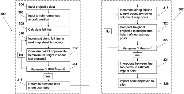
an impact point calculation processing unit that directly compares the fall line with the digital terrain map, by incrementally comparing a height of the projectile along the fall line with a height of the terrain by searching map data in the stored digital terrain map according to a coarse search of the digital terrain map and then according to a fine search of the digital terrain map in order to find an expected impact point on the terrain; and
an output processing unit comprising an aircraft display that displays, to a pilot, the expected impact point on the terrain;
wherein, during the coarse search of the digital terrain map, the impact calculation unit:
increments along the fall line to a boundary of a map sheet, the map sheet comprising a subset of the map posts in the stored digital terrain map, the subset comprising a plurality of map posts;
calculates a maximum height of terrain in the map sheet; and
compares a height of the projectile at the map sheet boundary to the maximum height of terrain in the map sheet.
|