| CPC G08G 1/0112 (2013.01) [G08G 1/0129 (2013.01); G08G 1/0133 (2013.01); G08G 1/0141 (2013.01)] | 21 Claims |
|
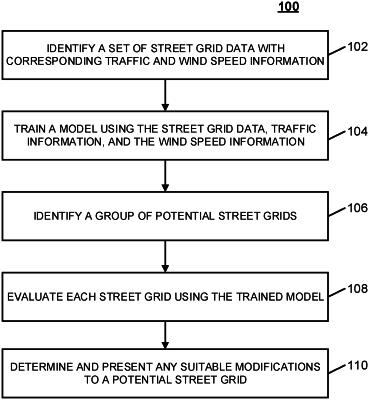
1. A method for generating and evaluating street grids, the method comprising:
receiving, using a hardware processor, street grid information corresponding to a plurality of locations, wherein the street grid information corresponding to a location in the plurality of locations is associated with vehicular traffic information;
training, using the hardware processor, a pedestrian comfort model using the street grid information and the vehicular traffic information from each of the plurality of locations, wherein an output of the pedestrian comfort model is a predicted pedestrian comfort score that is based on traffic congestion from the vehicular traffic information;
receiving, using the hardware processor, a plurality of potential street grids;
evaluating, using the hardware processor, each potential street grid in the plurality of potential street grids using the trained pedestrian comfort model, wherein the trained pedestrian comfort model generates predicted pedestrian comfort scores for portions of each potential street grid;
generating an interactive augmented map of each potential street grid that presents, upon receiving a selection of a portion of a potential street grid, the predicted pedestrian comfort scores for the selected portion; and
providing, using the hardware processor, the interactive augmented map to a user device.
|