| CPC G06F 30/20 (2020.01) | 8 Claims |

|
1. An early warning method for safety production risk of tailings pond based on risk ranking, comprising:
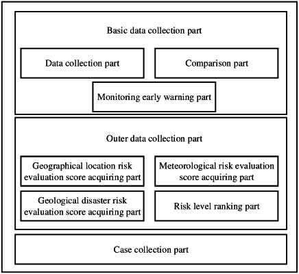
monitoring and collecting internal basic data of a tailings pond in real-time; and performing a basic monitoring and a basic early warning based on the internal basic data of the tailings pond;
collecting geographical location data, meteorological data, and historical geological disaster data of an area where the tailings pond is located in real-time; performing risk ranking on a safety production risk of the tailings pond based on the meteorological data and the historical geological disaster data, thereby obtaining a risk level of the tailings pond; and the risk level being one of a low risk level, a medium risk level, or a high risk level; and
collecting case data of global tailings pond accidents and hazard degree data of the global tailings pond accidents, acquiring accident solution strategies for the global tailings pond accidents, performing management and monitoring on the tailings pond by combining the accident solution strategies with the risk level, setting parameters in a process of the basic monitoring based on the risk level, and performing a ranked early warning on the safety production risk of the tailings pond based on the risk level;
wherein the collecting geographical location data, meteorological data, and historical geological disaster data of an area where the tailings pond is located in real-time; performing risk ranking on a safety production risk of the tailings pond based on the meteorological data and the historical geological disaster data, thereby obtaining a risk level of the tailings pond; and the risk level being one of a low risk level, a medium risk level, or a high risk level comprises:
monitoring and collecting the geographical location data of the area where the tailings pond is located, and acquiring a geographical location risk evaluation score by combining the geographical location data with a geographical location evaluation model;
monitoring and collecting the meteorological data of the area where the tailings pond is located, and acquiring a meteorological risk evaluation score by combining the meteorological data with a meteorological evaluation model;
collecting the historical geological disaster data of the area where the tailings pond is located, and acquiring a geological disaster risk evaluation score by combining the historical geological disaster data with a geological disaster evaluation model; and
combining the geographical location risk evaluation score, the meteorological risk evaluation score, and the geological disaster risk evaluation score to obtain the risk level being one of the low risk level, the medium risk level, or the high risk level;
wherein the monitoring and collecting the geographical location data of the area where the tailings pond is located, and acquiring a geographical location risk evaluation score by combining the geographical location data with a geographical location evaluation model comprises:
determining whether the area where the tailings pond is located is in an earthquake belt area through a survey, and collecting historical earthquake record data of the area where the tailings pond is located;
determining whether the area where the tailings pond is located is in a typhoon area through a survey, and collecting historical typhoon record data of the area where the tailings pond is located;
determining whether the area where the tailings pond is located is in a tsunami area through a survey, and collecting historical tsunami record data of the area where the tailings pond is located; and
combining the historical earthquake record data, the historical typhoon record data, and the historical tsunami record data with the geographical location evaluation model to acquire the geographical location risk evaluation score;
wherein the geographical location evaluation model is as follows:
    where F1 represents the geographical location risk evaluation score; P1 represents an earthquake evaluation coefficient, P2 represents a typhoon evaluation coefficient, and P3 represents a tsunami evaluation coefficient; n represents the number of earthquakes occurring in the area, m represents the number of typhoons occurring in the area, and q represents the number of tsunamis occurring in the area; Hd represents an average value of levels of the earthquakes occurring in the area, Ht represents an average value of levels of the typhoons occurring in the area, and Hh represents an average value of levels of the tsunamis occurring in the area; Jd represents an average duration of the earthquakes occurring in the area, Jt represents an average duration of the typhoons occurring in the area, and Jh represents an average duration of the typhoons occurring in the area; Ti represents an occurrence moment of an i-th earthquake, Ti+1 represents an occurrence moment of an i+1-th earthquake, Tj represents an occurrence moment of a j-th typhoon, Tj+1 represents an occurrence moment of a j+1-th typhoon, Tk represents an occurrence moment of a k-th tsunami, and Tk+1 represents an occurrence moment of a k+1-th tsunami.
|