| CPC G05D 1/0219 (2013.01) [G05D 1/0238 (2013.01); G05D 1/0246 (2013.01); G05D 1/027 (2013.01); G06V 20/10 (2022.01)] | 20 Claims |

|
1. A system for finding a new area to cover by a robot performing an area coverage task of an unexplored area, including:
a mobile platform having disposed thereon:
at least one camera;
a multi-axis inertial measuring unit (IMU) including at least one selected from one or more accelerometers and one or more gyroscopes; and
an interface to a host including one or more processors coupled to memory storing computer instructions to correct at least some estimated poses and locations of at least some 3D points from a 3D point cloud of features from images that define a map, the map used to provide an occupancy grid mapping that provides guidance to the mobile platform with distance calculation and the multi-axis inertial measuring unit (IMU), which computer instructions, when executed on the processors, implement actions comprising:
detecting based upon a sensory input received from a set of sensors including at least one non-tactile sensor being monitored while performing the area coverage task, an obstacle present in the robot's path, and whenever an obstacle's presence is detected:
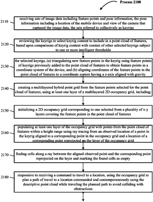
searching for an unknown space candidate in the occupancy grid mapping generated by using sensory input from the set of sensors to update the 3D point cloud that is used to update the occupancy grid; and
initiating motion to move the robot to a first waypoint of a set of waypoints in a path to the unknown space candidate that avoids the obstacle detected.
|