| CPC G01V 20/00 (2024.01) [G06Q 10/04 (2013.01); G06Q 50/02 (2013.01); G09B 25/06 (2013.01)] | 21 Claims |

|
1. A device comprising:
a processor; and
a memory device connected to the processor, the memory device including instructions that, when executed by the processor, cause the processor to:
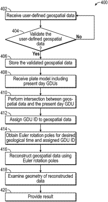
obtain, from at least one server accessed over a network, a plate model, wherein the plate model includes one or more geodynamic units (GDUs), each GDU including a GDU identifier, each GDU representing a different geological region;
receive a user-defined geospatial data of a desired geological region;
perform an intersection operation between the user-defined geospatial data and the plurality of GDUs of the plate model, the intersection operation assigning one of the GDU identifiers to the user-defined geospatial data;
obtain, from at least one of the servers, one or more Euler rotation poles, each Euler rotation pole based on a user-specified geological age, each Euler rotation pole being associated with one of the GDUs via the GDU identifier of the associated GDU; and
reconstruct the user-defined geospatial data to the user-specified geological age using the Euler rotation pole for the user-specified geological age at the assigned GDU identifier, the reconstruction a reconstructed paleogeographic position of the user-defined geospatial data at the user-specified geological age.
|