| CPC G01C 21/32 (2013.01) [B60W 60/001 (2020.02); G01C 21/3614 (2013.01)] | 13 Claims |

|
1. A method for creating a digital map, comprising the following steps:
receiving, by a vehicle-external server, measured data of at least one sensor from at least one mapping vehicle, via a first wireless communication link;
ascertaining, by the vehicle-external server, positions and orientations of the mapping vehicle via a SLAM method based on the received measured data;
generating, by the vehicle-external server, the digital map based on the received measured data, and the ascertained positions and orientations of the mapping vehicle;
receiving data of at least one road course from a database, or ascertaining the data of the at least one road course from the positions of the mapping vehicle;
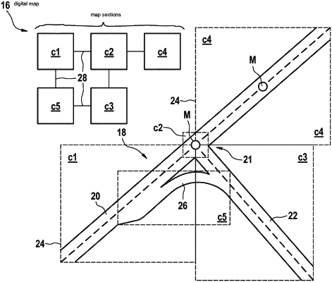
subdividing, by the vehicle-external server, the digital map into at least two map sections, which form at least one part of the digital map;
wherein the map sections are created along the road course, each map section of the map sections including respective connection information stored in the map section, the respective connection information of the map sections being related to one another, and corresponding with the road course, the respective connection information of a first map section of the map sections including a link to at least one other map section of the map sections, the link providing information about how the road course extends beyond the first map section, and wherein the respective connection information of each map section of at least one of the map sections includes links to at least two other map sections of the map sections, the links being based on a junction of the road course, the junction of the road course being an intersection of two or more different roads;
providing, by the vehicle-external server, the map sections and the respective connection information of the map sections, to a requesting vehicle, via a second wireless communication link; and
performing, by the requesting vehicle, automated driving functions using the provided map sections.
|