| CPC G06T 3/0068 (2013.01) [G06F 18/22 (2023.01); G06T 5/009 (2013.01); G06T 7/73 (2017.01); G06T 2207/10032 (2013.01); G06T 2207/30184 (2013.01)] | 23 Claims |
|
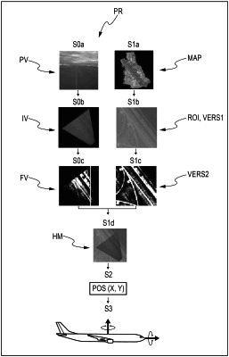
1. A device for locating a craft, notably an aircraft and/or a spacecraft comprising:
a database including a digital mapping of a terrain,
an acquisition unit configured to acquire a preliminary version of a digital image of said terrain, and
a processing unit configured to:
receive the preliminary version of the digital image from said acquisition unit;
transform the preliminary version of the digital image into an intermediate version of said digital image, wherein said intermediate version corresponds to a projection of said preliminary version onto a plane corresponding to a plane of said digital mapping;
augment and/or invert a contrast of said intermediate version of the digital image to obtain a final version of the digital image, wherein a contrast of the final version of the digital image is increased as compared to the contrast of the intermediate version of the digital image,
retrieve a first format of a digital map from the database,
augment a contrast of the first format of the digital map to form a final format of the digital map, wherein a contrast of the final format is increased as compared to a contrast of the first format of the digital map,
determine a similarity between the final format of the digital map and the final version of the digital image, and
determine a position of said craft based on the similarity of the final format of the digital map and the final version of the digital image.
|