| CPC G01C 21/3407 (2013.01) [G01C 21/3848 (2020.08); G01C 21/3881 (2020.08); G01S 17/86 (2020.01); G01S 17/89 (2013.01); G01S 17/931 (2020.01); G05D 1/0214 (2013.01); G06F 18/251 (2023.01); G06V 10/803 (2022.01); G06V 20/58 (2022.01); G05D 2201/0213 (2013.01)] | 15 Claims |
|
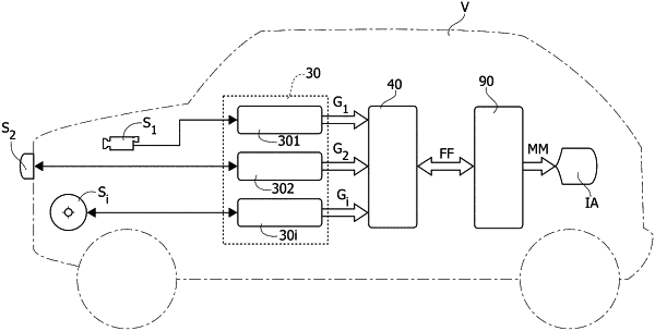
1. A method for vehicle (V) environment mapping, comprising the steps of:
receiving a set of input values (Y1, Y2, Yi) from a plurality of sensors (S1, S2, Si), applying temporal fusion processing to said set of input values (Y1, Y2, Yi), resulting in a respective set of occupancy grid maps (G1, G2, Gi),
applying data fusion processing to said set of occupancy grid maps (G1, G2, Gi) at least one of:
Bayesian Inference/Bayesian Occupancy Filter, resulting in a set of fused occupancy grid maps (FF), and
processing said set of fused occupancy grid map (FF), said processing operation comprising performing an arbitration of conflict in said set of fused occupancy grid maps (FF) and outputting a set of arbitrated fused occupancy grid maps (MM), in particular an arbitrated fused occupancy grid map (M) of drivable spaces,
wherein said processing said set of fused occupancy grid map (FF) further comprises:
flagging a set of grid cells (CA), preferably said set of grid cells (CA) comprising grid cells classified as uncertain, in said at least one fused map (F; E),
applying said set of compounding rules (CR) to grid cells in said at least one fused map (F; E), providing a set of compound grid cells values (CC),
providing said fused occupancy grid map of drivable spaces (M), comprising incorporating said set of compound grid cells values (CC) in the at least one fused map (F; E),
wherein applying a data fusion processing to said set of sensors occupancy grid maps (G1, G2, Gi) comprises a Bayesian Inference/Bayesian Occupancy Filter resulting in a fused occupancy grid map (F), and comprises detecting discrepancies by comparing occupancy grid maps in said set of maps (G1, G2, Gi), resulting in a set of detected discrepancies (D, Δ12, Δ2i, Δi1).
|