| CPC A01B 79/005 (2013.01) [A01B 33/10 (2013.01); G06N 20/00 (2019.01); G06T 17/05 (2013.01)] | 19 Claims |
|
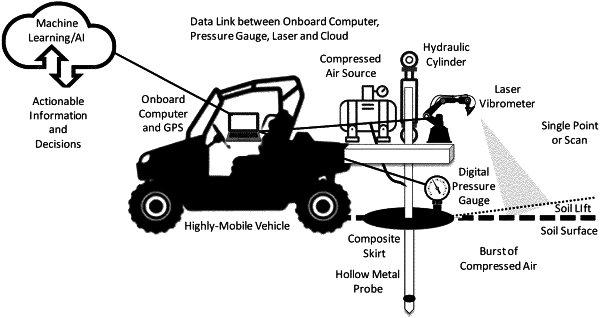
1. A system comprising:
a soil disruption device that is configured to cause a disruption of a subsurface portion of soil at a compaction detection location;
a disruption sensor that is configured to generate disruption data corresponding to the disruption of the subsurface portion of the soil at the compaction detection location;
a location device that is configured to provide geographic location data corresponding to the compaction detection location; and
a processor circuit that is configured to receive the geographic location data from the location device and the disruption data from the disruption sensor and to associate the geographic location data with the disruption data, wherein the processor circuit comprises machine learning computer program product that, when executed by the processing circuit, generates machine learning operations that are configured to generate three-dimensional soil compaction and tilth maps using data corresponding to injection of compressed air and laser vibrometry.
|