| CPC G01C 11/02 (2013.01) [G01C 21/3848 (2020.08); G01C 21/387 (2020.08); G06F 16/29 (2019.01); G06T 3/4038 (2013.01); H04N 1/3876 (2013.01); H04N 5/77 (2013.01)] |
| Attention is directed to the decision of Vederi, LLC v. Google LLC., No. 22-1477, 1478, 1479, 1480 (Fed. Cir. 2023). This reexamination may not have resolved all questions raised by this decision. See 37 CFR 1.552(c) for ex parte reexamination and 37 CFR 1.906(c) for inter partes reexamination. |
| AS A RESULT OF REEXAMINATION, IT HAS BEEN DETERMINED THAT: |
| Claims 1-6, 8-10, 13-18, 20-38, 41-49, 51-61, 63-68, and 70-72 are cancelled. |
| Claims 7, 11, 12, 19, 39, 40, 50, 62, 69, 73, and 74 were not reexamined. |
|
receiving a first user input specifying a first location in the geographic area;
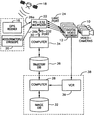
retrieving from the image source a first image associated with the first location, the image source providing a plurality of images depicting views of objects in the geographic area, the views being substantially elevations of the objects in the geographic area, wherein the images are associated with image frames acquired by an image recording device moving along a trajectory;
displaying on the screen a direction identifier for indicating the viewing direction depicted in the first image;
receiving a second user input specifying a navigation direction relative to the first location in the geographic area;
determining a second location based on the user specified navigation direction; and
retrieving from the image source a second image associated with the second location.
|