| CPC G01C 21/3638 (2013.01) [B60W 60/00253 (2020.02); B62D 15/0285 (2013.01); G01C 21/365 (2013.01); G05D 1/0044 (2013.01); G05D 1/0088 (2013.01); G05D 1/0212 (2013.01); G05D 1/0246 (2013.01); G05D 1/0274 (2013.01); G06F 18/24 (2023.01); G06T 7/20 (2013.01); G06V 20/56 (2022.01); B60W 2420/403 (2013.01); B60W 2420/408 (2024.01); B60W 2554/00 (2020.02); B60W 2555/20 (2020.02); B60W 2556/10 (2020.02); G06T 2207/30252 (2013.01); G06T 2207/30256 (2013.01); G06T 2207/30261 (2013.01)] | 20 Claims |
|
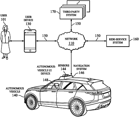
1. A method comprising, by a computing system:
receiving a transportation request that specifies an area to pick up or drop off a user;
determining a plurality of available locations for a vehicle to pick up or drop off the user in the area based on sensor data that is captured by the vehicle and is associated with physical characteristics of the area:
calculating a viability value for each of the plurality of available locations, wherein the viability value is calculated based on the physical characteristics of the area as determined from the sensor data:
ranking the plurality of available locations according to the viability values of the plurality of available locations, wherein an available location with a higher viability value is ranked above an available location with a lower viability value;
providing for display, on a computing device associated with the user, one or more visual representations that indicate one or more selectable locations of the plurality of available locations based on the ranking;
receiving, by the computing device associated with the user, a selection by the user that indicates a selected location from the one or more selectable locations; and
providing for display, on the computing device associated with the user, a navigation route to the selected location from the one or more selectable locations.
|