| CPC G06T 7/74 (2017.01) [G01S 17/89 (2013.01); G06T 7/10 (2017.01); G06V 10/22 (2022.01); G06V 10/52 (2022.01); G06V 10/761 (2022.01); G06V 10/774 (2022.01); G06V 10/82 (2022.01); G06V 20/70 (2022.01); G06T 2207/10028 (2013.01); G06T 2207/20021 (2013.01); G06T 2207/20081 (2013.01); G06T 2207/20084 (2013.01); G06T 2207/30242 (2013.01); G06T 2207/30244 (2013.01)] | 17 Claims |
|
1. A visual positioning system, comprising:
at least one storage medium including a set of instructions for visual positioning;
at least one processor configured to communicate with the at least one storage medium, wherein when executing the set of instructions, the at least one processor is configured to direct the system to:
obtain a positioning image collected by an imaging device;
obtain a three-dimensional (3D) point cloud map associated with an area where the imaging device is located;
determine, based on the positioning image, a target area associated with the positioning image from the 3D point cloud map; and
determine, based on the positioning image and the target area, positioning information of the imaging device, wherein to determine, based on the positioning image and the target area, positioning information of the imaging device, the at least one processor is configured to direct the system to:
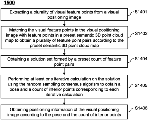
extract at least one visual feature point in the positioning image;
match the at least one visual feature point with feature points in the target area to obtain at least one feature point pair, the at least one feature point pair including at least one of at least one feature point pair with a semantic annotation or at least one feature point pair without a semantic annotation; and
calculate, based on the at least one feature point pair, the positioning information of the imaging device.
|