| CPC G06Q 10/087 (2013.01) [G06Q 10/06315 (2013.01); G06Q 10/0639 (2013.01); G06Q 50/02 (2013.01)] | 20 Claims |
|
1. A method comprising:
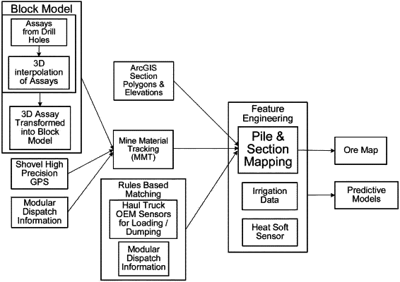
receiving, by one or more processors, location coordinates of vehicles making dumps on a lift of a stockpile;
aggregating and averaging, by the one or more processors, the location coordinates of the vehicles to determine a location of the vehicles; and
determining, by the one or more processors, a dump location by comparing the location of the vehicles with geographic information system (GIS) polygons and dispatch data,
wherein the GIS polygons include a GIS object that stores a geographic representation as a property of the GIS object, and
wherein the geographic representation includes a series of x and y coordinate pairs that enclose an area of the stockpile;
adjusting, by the one or more processors, the dump location by removing errors due to a periodic overlap in the GIS polygons;
adjusting, by the one or more processors, the dump location by removing errors due to the dispatch data recording a beacon dump location that is different than the dump location;
adjusting, by the one or more processors, the dump location by removing entry errors about the dump location;
adjusting, by the one or more processors, a location of leaching operations based on the dump location; and
adjusting, by the one or more processors, the leaching operations by activating a mining machine to pump raffinate into the adjusted location of the leaching operations, to optimize mining production at the dump location.
|