| CPC A01D 41/1275 (2013.01) [A01D 41/1217 (2013.01); A01D 41/1278 (2013.01)] | 4 Claims |
|
1. An apparatus, comprising:
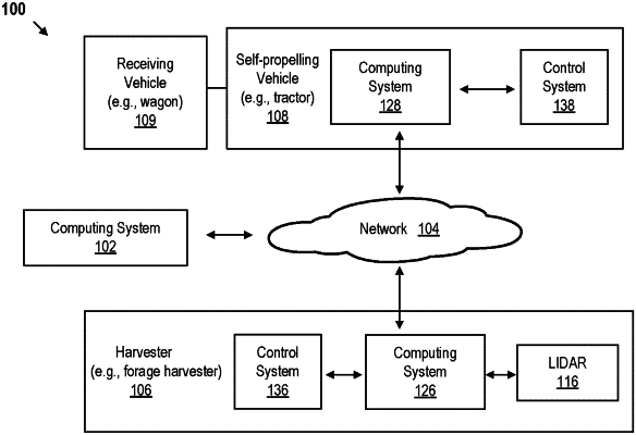
a camera, configured to capture image data of a receiving vehicle and a self-propelling vehicle moving the receiving vehicle that is near a harvester;
a LIDAR system, configured to:
scan in coordinates of parts of the receiving vehicle and the self-propelled vehicle; and
scan in coordinates of a distribution of crop material in the receiving vehicle; and
a computing system, configured to:
convert the scanned in coordinates of the receiving vehicle, the self-propelled vehicle and the distribution of crop material into a point cloud;
detect an image of the receiving vehicle from the image data;
generate a bounding box that surrounds the detected imaged of the receiving vehicle, wherein the bounding box is either a rectangular cuboid or a rectangle;
detect boundaries of the receiving vehicle using edge detection, within the generated bounding box;
estimate fill level based on the detected boundaries and the point cloud;
time-match the captured image data and the point cloud to provide time-matched data;
extract a receiving vehicle portion of the point cloud based on the time-matched data and the detected image of the receiving vehicle;
estimate dimensions and orientation of the receiving vehicle based on the point cloud; and
generate graphical representations of the estimated fill level and the estimated dimensions and orientation of the receiving vehicle to be displayed on a screen simultaneously.
|