| CPC G06T 19/006 (2013.01) [B60K 35/00 (2013.01); G06F 3/013 (2013.01); B60K 35/10 (2024.01); B60K 35/22 (2024.01); B60K 35/28 (2024.01); B60K 2360/149 (2024.01); B60K 2360/177 (2024.01); B60K 2360/31 (2024.01); B60K 2360/48 (2024.01)] | 12 Claims |
|
1. A method for displaying infrastructure information on a multi-focal plane augmented reality display of a vehicle, comprising:
receiving infrastructure data, wherein the infrastructure data includes information about a location of at least one infrastructure along a route of the vehicle and the at least one infrastructure is at least one point-of-interest (POI) along the route of the vehicle;
receiving vehicle-location data, wherein the vehicle-location data includes information about a location of the vehicle;
determining a position of the vehicle relative to the location of the least one infrastructure using the infrastructure data and the vehicle-location data;
determining a size of a virtual image based on a distance from the vehicle to the at least one infrastructure along the route of the vehicle, wherein the size of the virtual image is inversely proportional to the distance from the vehicle to the at least one infrastructure;
receiving a selection from a user, wherein the selection is indicative of a type of the at least one POI that the user wants identified on the multi-focal plane augmented reality display, the multi-focal plane augmented reality display shows solely the virtual image associated with the type of the at least one POIs selected by the user, the infrastructure information is information about the POI, the virtual image includes a graphical item, and the graphical item is a trademark identifying the POI;
determining whether the at least one POI is located along the route of the vehicle using the infrastructure data; and
in response to determining that the at least one POI is located along the route of the vehicle, displaying the virtual image on the multi-focal plane augmented reality display, wherein the virtual image includes information about the at least one POI located along the route of the vehicle;
transmitting a command signal to the multi-focal plane augmented reality display to display the virtual image showing the infrastructure information of the at least one infrastructure on the multi-focal plane augmented reality display; and
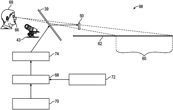
wherein the multi-focal plane augmented reality display has a first image plane and a second image plane, the first image plane and the second image planes are at different locations, the first image plane shows a view of an outside world, a second image plane is reserved for displaying the virtual image, and the second image plane appears at a location farther on a roadway surface relative to the first image plane while the vehicle travels along the roadway surface, the second image plane starts at a first predetermined distance from the vehicle and ends at a second predetermined distance, the second predetermined distance is greater than the first predetermined distance, the second image plane includes a first linear boundary arranged horizontally relative to the roadway surface, the first linear boundary is at the first predetermined distance from the vehicle, the second image plane is delimited by a sloped linear boundary that starts at the first predetermined distance from the vehicle and ends at a third predetermined distance from the vehicle, the sloped linear boundary is obliquely angled relative to the first linear boundary, the third predetermined distance is greater than the first predetermined distance, the third predetermined distance is less than the second predetermined distance, and the second image plane includes a second linear boundary that is arranged parallel to the roadway surface, the slopped linear boundary is obliquely angled relative to the second linear boundary, and the second linear boundary starts at the third predetermined distance from the vehicle and ends at the second predetermined distance from the vehicle.
|