| CPC G01S 19/48 (2013.01) [G01S 19/31 (2013.01); G01S 19/45 (2013.01); G01C 5/06 (2013.01); G01S 19/05 (2013.01); G01S 19/40 (2013.01); H04W 4/025 (2013.01)] | 17 Claims |
|
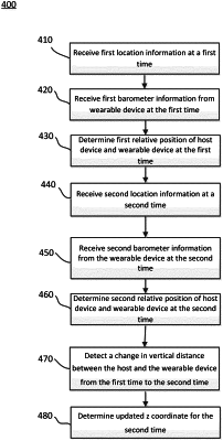
8. A method of determining elevation information, comprising:
receiving, with one or more processors, first location information from a navigation system at a first time;
receiving, with the one or more processors, first barometric information from a wearable accessory at the first time;
receiving, with one or more processors, second location information from the navigation system at a second time;
receiving second barometric information from the wearable accessory at the second time;
detecting, with the one or more processors, a change in vertical distance between a portable electronic device and the wearable accessory from the first time to the second time;
determining, with one or more processors, updated second location information, including at least a z coordinate for the second time, based on the second location information, the first and second barometric information, and the change in vertical distance; and
providing turn-by-turn navigation instructions using the updated second location information.
|