| CPC G01C 21/3626 (2013.01) [G01C 21/3617 (2013.01); G01S 19/42 (2013.01); G06F 3/04842 (2013.01); F04B 43/043 (2013.01); G01C 21/3614 (2013.01)] | 3 Claims |
|
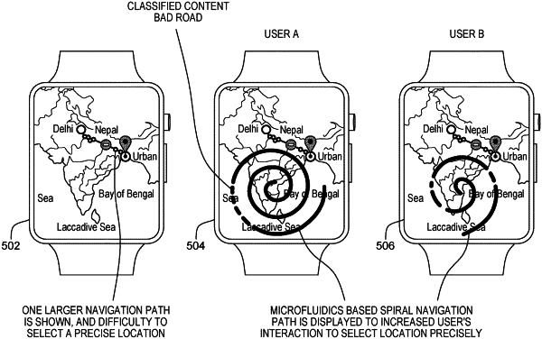
1. A computer-implemented method (CIM) for use with a microfluidic display device that includes a flat display panel and microfluidic hardware that is configured to selectively produce raised areas on the flat display panel, the CIM comprising:
receiving map data that represents a geographic area that includes a set of roads;
receiving trip data that includes a starting point, a destination point and an identification of a route along the set of roads that extends from the staring point to the destination point;
receiving road construction data including data indicative of a first road construction site along the route; and
providing a raised spiral representation of the route on the flat display panel of the microfluidic display device with the length of the raised spiral representation being proportional to the length of the route, and with the raised spiral representation of the road including a tactile indication of the first road construction site at a scaled location, wherein the scaled location is located with respect to the length of the route so that a user is able to run a finger along the raised spiral representation to get some indication of where the first road construction site is relative to the length of the route without looking at the flat display panel.
|