| CPC G01C 21/30 (2013.01) | 20 Claims |
|
1. A system for vehicle localization, comprising:
a data processing system comprising memory and one or more processors to:
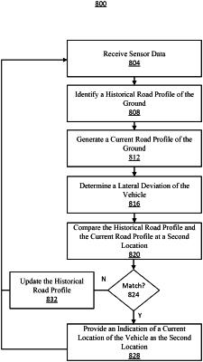
receive, via one or more sensors on the vehicle, sensor data comprising vertical velocity data, longitudinal velocity data, and a plurality of vertical displacement signals indicating vertical displacement between a body of the vehicle and a ground on which the vehicle traverses;
identify, for a first location of the vehicle, a historical road profile of the ground indicative of vertical displacements between the body of the vehicle and the ground at a plurality of locations including the first location;
normalize the vertical velocity data associated with the longitudinal velocity data to a predetermined velocity;
generate a current road profile of the ground based on the sensor data comprising the longitudinal velocity data, the vertical velocity data normalized to the predetermined velocity, and the plurality of vertical displacement signals;
determine, based on lateral displacement data received via the one or more sensors, a lateral deviation of the vehicle;
determine a match between the historical road profile and the current road profile at a second location subsequent to the first location that aligns with the lateral deviation; and
provide, responsive to the match, an indication of a current location of the vehicle as the second location stored in the historical road profile that aligns with the lateral deviation.
|