| CPC G06V 20/58 (2022.01) [G01S 7/4808 (2013.01); G01S 17/08 (2013.01); G01S 17/58 (2013.01); G01S 17/66 (2013.01); G01S 17/86 (2020.01); G01S 17/88 (2013.01); G01S 17/931 (2020.01); G08G 1/166 (2013.01)] | 20 Claims |
|
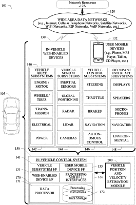
1. A system comprising:
a data processor; and
a vehicle position and velocity estimation module which, when executed by the data processor, causes the system to:
receive input object data from a subsystem of vehicle, the input object data including image data from an image generating device and distance data from a distance measuring device, the distance measuring device comprising one or more light imaging, detection, and ranging (LIDAR) sensors;
determine a first position of a proximate object near the vehicle from the image data;
determine a second position of the proximate object from the distance data, the second position being tracked using the distance data received from the distance measuring device over a plurality of processing cycles, the distance data being collected during at least one of the plurality of processing cycles;
correlate the first position and the second position by matching the first position of the proximate object detected in the image data with the second position of the same proximate object detected in the distance data;
determine a three-dimensional (3D) position of the proximate object using the correlated first and second positions; and
use the 3D position of the proximate object to navigate the vehicle.
|